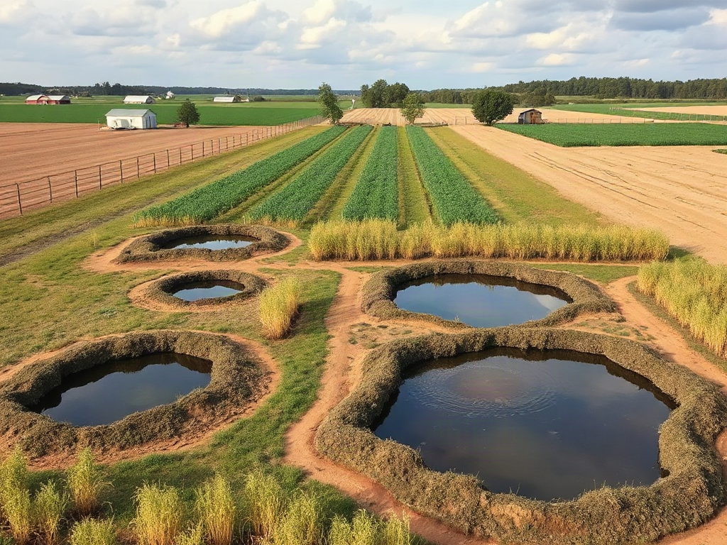
A self-sufficient farm layout should organize water, food, and access around the land’s contours, soil capability, and daily workload rather than dividing the property into equal blocks. Protect the water source uphill from contamination, place frequently tended crops near the house, and connect barns, fields, and storage with an all-weather lane that does not interrupt drainage. Reserve lower or wetter ground for ponds, managed grazing, or suitable perennial crops instead of buildings. Before construction, map runoff paths, vehicle turning needs, utility routes, winter conditions, and emergency access; moving a gate is inexpensive, but correcting a poorly placed barn, pond, or road is not.
Map the Land Before Assigning Uses
The first layout drawing should record existing conditions, not proposed buildings. Mark property boundaries, contour direction, high and low points, seasonal wet areas, soil changes, mature trees, prevailing winds, utilities, wells, streams, culverts, and every established entrance. A farm arranged without this base map may look orderly on paper while placing a barn in a runoff path or requiring tractors to cross productive soil several times a day.
Observe the property during more than one type of weather. A shallow swale that is invisible in summer may carry concentrated water during spring rain. A firm-looking lane may become impassable after repeated freeze-thaw cycles. Walk the site after a hard rain and note where water enters, slows, ponds, and exits. During dry weather, check where vegetation remains green and where soil cracks or becomes powdery. These observations reveal hydrology that a flat aerial image cannot show.
Divide the land into capability areas rather than equal rectangles. Stable, well-drained ground near existing utilities is usually more valuable for buildings than a scenic low spot. Deep, accessible soil may justify annual crop production, while steep or erosion-prone ground may be better kept under perennial vegetation, orchard cover, managed grazing, or woodland. Keep flood-prone ground free of irreplaceable infrastructure even if it is convenient to the road.
A useful first-pass map can use transparent layers for water, food production, structures, and movement. Test each proposed feature against the other layers. For example, an orchard planted directly below a livestock concentration area could receive nutrient-rich runoff, while a vegetable plot beyond the machinery yard may be exposed to dust, traffic, and soil compaction. Conflict mapping is more informative than simply asking whether a feature physically fits.
Do not treat the current homestead routine as permanent. A property managed by two adults today may later need easier vehicle access, shorter walking distances, or room for hired help. The practical implication is to preserve options: leave expansion space beside the barn, protect a future utility corridor, and avoid planting long-lived trees where another water line or lane is likely to be needed. A sound Self-sufficient farm layout for water, food, and access begins with constraints that are expensive or impossible to change.
Build the Water Layout Around Gravity and Protection
Water planning has three distinct jobs: secure clean household water, supply crops and livestock, and move excess runoff without damaging roads or soil. These jobs may share infrastructure, but they should not be treated as interchangeable. Drinking-water sources require protection from manure, fuel, septic systems, chemical storage, and surface runoff. Irrigation storage can accept different treatment and distribution arrangements, subject to local rules and the crops being watered.
Place the clean-water source and its protection area before siting intensive livestock facilities. Wells should be located and constructed according to applicable health, environmental, and setback requirements; a convenient spot is not automatically a safe spot. Direct clean roof water away from manure areas, and keep livestock from trampling streambanks or pond edges used for water storage. Where animals need pond water, a fenced pond with a controlled watering point or pumped trough may protect banks better than unrestricted access.
Gravity can reduce pumping demands when elevation allows it. A tank above a garden may provide useful pressure, while a pond below the fields may require pumping whenever irrigation is needed. That does not make the lower pond wrong—it may be the natural runoff collection point—but the energy and maintenance cost must be included in the decision. Conversely, forcing a pond onto high ground without suitable soils, watershed area, or professional design can create leakage or structural risk.
Trace a complete water path from source to use and then to discharge. Include shutoff valves, overflow routes, frost protection, filtration appropriate to the use, and access for repairs. A roof-catchment tank needs a stable foundation and a safe overflow that does not erode the building pad. A livestock line should be isolated in sections so one broken hydrant does not disable the entire farm. Irrigation zones should match crop demand and available flow rather than assuming every bed can run at once.
Signs of a workable system include clear water-source protection, accessible valves, stable pond banks, and runoff that crosses lanes through designed culverts or broad drainage structures. Persistent puddles near foundations, algae-heavy livestock water, eroded spillways, sediment-filled ditches, or pumps running near their limit indicate that the layout is failing. Before excavating a pond or altering a stream or wet area, consult local authorities and qualified designers; permits, dam-safety rules, soils, and watershed size can determine whether the proposed location is viable.
Place Food Production by Labor, Soil, and Harvest Frequency
Food areas should be positioned according to how often they are visited and what their soil, water, and handling needs demand. Salad beds, herbs, seedlings, laying hens, and milking animals generate frequent trips, so distance quickly becomes a labor cost. Grain plots, hay ground, woodlots, and mature orchards generally tolerate greater separation because they receive fewer daily visits.
A compact kitchen garden near the house usually performs better operationally than a larger garden at the far end of the property. The close garden is easier to inspect for irrigation leaks, animal damage, weeds, and harvest readiness. It can also sit near washing and storage space. Yet proximity should not override site fitness: heavy shade, compacted fill, roof runoff, or contaminated soil may justify placing the main beds farther away and using the closest area for containers, propagation, or tools.
Organize production into blocks with specific support needs. Annual vegetables benefit from reliable irrigation, compost access, crop rotation space, and deer-resistant fencing where pressure exists. Orchards need suitable drainage, air movement, pollination planning, and enough room for mature canopies and equipment. Grazing areas require water distribution, animal movement routes, shade or shelter where appropriate, and a place to hold animals without damaging the pasture during wet periods.
Consider the flow after harvest as carefully as the growing site. Produce may move from field to wash area, then to cool storage, preservation, feed use, or compost. Livestock feed should travel from delivery or storage to the animals without crossing the household yard repeatedly. A root cellar that stays cool but requires carrying every crate down a steep, muddy path is poorly integrated. The shortest route is not always best; a slightly longer firm route may be safer and usable throughout the year.
Use a compact priority check before assigning a food block:
- Frequency: How many visits will this enterprise require on an ordinary day?
- Fit: Does the soil, slope, sun exposure, and drainage suit the intended crop or animal?
- Inputs: Can water, feed, compost, fencing supplies, and tools reach it efficiently?
- Outputs: Where will harvests, manure, wash water, and spoiled material go?
- Failure access: Can a vehicle reach the area when an animal is injured, a pump fails, or a crop must be harvested quickly?
A common mistake is maximizing planted acreage before proving the farm’s labor and water capacity. Begin with a smaller, well-served production core and preserve adjacent expansion ground. This approach produces better information about actual yields, pest pressure, irrigation demand, and chore time than scattering enterprises across the full property during the first season.
Design Access for Chores, Deliveries, and Emergencies
Farm access must work for the largest necessary vehicle in poor conditions, not merely for a pickup truck on a dry afternoon. Map routes for feed deliveries, hay trailers, livestock transport, waste removal, fire response, ambulances, utility repair, and construction equipment. Confirm entrance width, overhead clearance, bridge or culvert capacity, turning radius, grade, surface strength, and space to turn around without backing a long distance.
A single main spine lane with short service branches often disturbs less land than multiple independent roads. Run it on stable ground and across contours only where drainage can be handled deliberately. Roads placed straight up and down a slope tend to collect and accelerate water; roads that block natural drainage can saturate the uphill edge and wash out downstream. Crowning, cross-slope shaping, ditches, water bars, and culverts are site-specific tools, not interchangeable decorations. Their spacing and capacity should reflect soil, slope, traffic, and local rainfall behavior.
Separate clean household movement from livestock and heavy-equipment traffic where practical. The front door should not open directly onto the route used by manure spreaders, feed trucks, and cattle trailers. At the same time, excessive separation creates long walks and duplicates infrastructure. A workable compromise is a shared entrance that divides into a household drive and a farm service lane before reaching the main activity areas.
Gate placement deserves careful attention. A gate at the bottom of a steep approach may force a driver to stop where traction is weakest. A narrow gate aligned at an angle to the lane makes trailers difficult to maneuver. Set gates back far enough that vehicles can leave the public road before stopping, where regulations and site dimensions permit. Provide firm footing at high-use gates and water points, since concentrated hoof and tire traffic can convert small wet areas into persistent mud.
Test the proposed layout with real movements before installing permanent fencing. Mark lane edges and gates with temporary stakes, then drive the expected tractor-and-trailer combination through the route. Carry feed, tools, and harvest crates along daily chore paths. Repeated reversing, tight corners, blind approaches, standing water, and frequent crossings between animals and vehicles are warning signs.
The access layer of a Self-sufficient farm layout for water, food, and access should remain serviceable when the farm is under stress. Maintain more than one way to isolate utilities, provide responders with clear property identification, and avoid placing fuel, hay, or parked machinery where it narrows the only route. All-weather access costs more initially than an unimproved track, but repairing rutting while feed or emergency vehicles wait can be more disruptive and expensive.
Frequently Asked Questions
What should be placed first on a self-sufficient farm map?
Map boundaries, contours, runoff, soils, existing water sources, utilities, roads, and restricted areas before placing new structures. These fixed conditions determine where buildings, ponds, crops, and lanes are likely to function reliably.
Should a vegetable garden always be next to the house?
It should be close when the nearby ground has adequate sun, drainage, clean soil, and irrigation access. If those conditions are poor, use the closest suitable site and create an efficient route to tools, washing, and storage.
Is the lowest point always the best location for a pond?
No. A pond location also depends on soils, watershed area, excavation feasibility, overflow safety, water quality, regulations, and distance from its intended uses. Professional evaluation may be needed before construction.
How wide should a farm access lane be?
Width should reflect the largest vehicle, required clearance, curves, roadside obstacles, and emergency-access rules. Test turning movements for trailers and delivery trucks rather than selecting a dimension based only on ordinary cars.
How can a farm layout be tested before permanent construction?
Use stakes to mark buildings, lanes, fences, and gates; observe runoff through wet weather; and rehearse vehicle and chore routes. Temporary fencing and a limited first production area expose layout conflicts at lower cost.
Further Reading
Authoritative Sources
- USDA Web Soil Survey
websoilsurvey.nrcs.usda.govSoil maps and interpretations can support early decisions about drainage, crop areas, roads, ponds, and building sites
- USDA Natural Resources Conservation Service State Offices
nrcs.usda.govState-specific NRCS contacts can help landowners find locally relevant conservation planning and technical resources
- EPA Private Drinking Water Wells
epa.govThis federal resource explains private-well responsibilities, testing considerations, and common contamination concerns
- Extension Foundation
extension.orgExtension resources connect farm-layout questions with regional information on soils, crops, livestock, and water management
Conclusion
Effective farm organization comes from fitting each use to the property rather than forcing a symmetrical design onto uneven land. Document water movement and soil limitations first, protect drinking-water sources, and reserve stable ground for structures that cannot tolerate flooding or settlement. Keep intensive food production within an efficient chore radius, while assigning less frequently visited uses to suitable outer areas. Roads and gates should accommodate deliveries, trailers, drainage, and emergency response under difficult seasonal conditions.
The next step is to produce a scaled base map and verify it on foot after rain. Mark one practical route connecting the home, production core, storage, and public road, then test proposed locations with temporary stakes. Delay permanent ponds, buildings, and orchard rows until water paths, turning movements, utility corridors, and future expansion space have been checked.